Age of the Earth – in a Nutshell

Q: In geology class my professor told me that the earth’s age is based of off meters how does this work

Thanks for your help

– Theo

A:

The age of the Earth was initially estimated by scientists by mapping stacks of sedimentary rocks in the UK, then measuring sedimentation rates in similar environments (lakes, rivers, seashore, etc.). In the 19th Century this initially gave startling – even shocking at the time – estimates in the hundreds of millions of years range. In the early 20th Century radioisotopes became available, and these were used to extend the age of the Earth into the billions (billion = thousand million) of years age range*. This physically meant measuring back to the point in time when the mineral hosting the radioisotopes and their daughter-products was last melted. THEN it just became a game of searching all over the Earth for the oldest date-able minerals with uranium and lead in them (for example, a zircon crystal). The oldest rocks found so far are in Greenland and western Australia, and based on these the Earth’s age is estimated to be at least 4.55 thousand million years old. This means it is at LEAST that old.

* Note that in some countries like the US, the word “billion” means a thousand million, while in other countries (e.g., the UK), the word “billion” means a million million.

How to contain Yellowstone…. or maybe not

As teachers we always want to encourage questions – not discourage questions. Sometimes, however, people will start with a question and then on their own figure out an “answer.” If the answer isn’t grounded in reality – some basic education being necessary here – then the answer can get out of control and move beyond reality very quickly. The following is an example of this.


Q: Could my strategy for fixing yellowstone work?

Build a huge reservoir container made of titanium, nickel,and cobalt. Then build a 4d scanning system that monitor the lava pressure within yellowstone as it increase. Build a drain made out of titanium,cobalt,nickel, using gravity slowly drain lava into reservoir as the lava pressure increases to maintain lava at the below level of erupting sustain it at that level as plates shift friction ignites gases in lava then lava increases so I do not think that cooling it will work sufficiently in my opinion. by keeping lava in core low in volcanoes maybe we can reduce friction of constant shifting plates. PLEASE write back.
–misty c


A: You are operating under a rather large number of mistaken assumptions.

First of all, friction does not ignite volcanic gases; they tend to be primarily SO2 and CO2, and both of them are already oxidized.  In other words, they can’t “ignite.”

Second, you cannot monitor lava pressure in “4D” or even 3D remotely – you can only guesstimate it from laboratory pressure-cell studies coupled with depth/thickness estimates from seismic reflection experiments.

Third, there is not enough money in the entire US GDP to pay for a container of titanium, nickle, and cobalt of any size that might be even remotely comparable to the output of even a small Yellowstone eruption.

Fourth, while such a container as you describe would probably not melt at typical magma temperatures (~1,300 C), it would be structurally weaker than at ambient temperatures. It would be a very complex engineering problem. Actually, why would you even need a container at all? The Earth’s surface is covered with vast sheets of cooled lava in many places, including Siberia, western India, and the Pacific Northwest.

Fifth, the Yellowstone caldera is nearly 45 miles (72 kilometers) across. There are several rough estimates from seismic data of how large the magma reservoir beneath it is, and they are all huge – and highly dependent upon how far down you want to count. Down to the top of the Mantle? Some recent research suggests that the Yellowstone hot spot plume rises from a depth of at least 440 miles (700 kilometers) deep within the Earth’s Mantle. Some researchers suspect it originates from 1,800 miles (2,900 kilometers) deep at the top of the Earth’s core. In other words, that is a LOT of magma. The last really large eruption 640,000 years ago blew out the equivalent of 1,000 cubic kilometers of DRE (dense rock equivalent). In other words, 240 cubic miles of rock blasted to tephra and ash that reached as far as the East Coast of the US.

Sixth, to “drain” something you would need pressure or gravity to work for you; no known pump could handle molten magma. Moreover, the current understanding is that the magma under Yellowstone is a highly-viscous, mostly-crystal mush (only a 2% – 9% melt fraction remains from seismic tomography data interpretation). An “eruptible” magma would require at least a 50% – 60% melt fraction.  The top of the magma now lies at least 4 miles (6 kilometers) below the Earth’s surface. It is already being contained by an overlying cap of volcanic rock left from previous eruptions that have now cooled. Experimental drilling to those sorts of depths is extraordinarily difficult. The Kola Peninsula Superdeep Borehole in Russia took two decades to reach six miles (10 kilometers) depth. It’s terminal aperture was just 9 inches/23 cm in diameter. Rock turns plastic before you get to those depths, closing in and trapping the drill-stem.

Just compare that 23 centimeter-diameter borehole to the width of the caldera at 72,405,000 centimeters. There is no way you could “drain” Yellowstone through a drill hole that small (even if the magma was hot, pressurized, and non-crystalline) in the all the time that the Earth has existed.

Finally, until you are actually physically standing on a volcano, you cannot really understand how immense it is. Volcanoes dwarf the creations of humankind. The forces involved in even a small to moderate eruption are far greater than anything mankind can develop with modern technology, including fusion bombs – and Yellowstone is a Supervolcano. All you can do is get out of the way when ANY volcano decides to do its thing.

I have not even begun to address the formidable engineering difficulties of your plan.

This may not be the kind of response you may have expected; I’m trying to give you a scale-based reality-check here. You can learn a lot more by reading some of the scientific literature, readily available on the internet, for instance:

http://science.sciencemag.org/content/348/6236/773?ijkey=c0dac9ef6421b172d426307cf7fa08be7986dee6&keytype2=tf_ipsecsha


Well, how big WAS it?

It is human nature to want to measure things, or at least calibrate big things against other big things. The big and destructive fairly beg quantifying, in fact, so for instance we have the Saffir-Simpson hurricane wind scale (with a top level of 5 for winds above 156 mph/250 kph). This depends only on wind velocities, and does not take into account either rain or storm surges (Allaby, 2008). We also have the Fujita tornado intensity scale (Fujita, 1971), which for winds above 261 mph/420 kph can reach a level of F5. The following question asks about measuring earthquakes and volcanoes, which are much harder to quantify than wind-speed velocities.


Q: Hi I am an 8th grade student and I was wondering what determines the magnitude of an earthquake or what determines the power of a volcano…

– Caleb Le M.


A: Your question has two parts, which I will answer in order:

  1. Earthquake magnitudes are calculated many different ways, but ultimately it comes down to measuring the amplitude of the actual ground motion (up-down, side-to-side) on multiple seismometers, and correcting for the varying seismic rock-velocities and the distance separating the seismometers from the earthquake epicenter. Of course, you have to calculate the distance to the epicenter first by triangulation from three or more seismometers (and also correct THOSE results by different seismic velocities in the different rocks between the hypocenter and the different measuring seismometers).

Asking a seismologist how big an earthquake was is like asking a friend to describe how big someone is? Do you mean tall? Wide? Heavy? Some combination of all of these? Does this dress make me look fat? Seismologists do NOT like being asked how they calculate a magnitude, because it will generally require a 30-minute explanation. Therefore, their first reply is often which magnitude are we talking about here?

The original earthquake magnitude scale (Richter, 1935) was the first coherent attempt to define something that is ultimately three-dimensional and very complex. The original Richter scale measured only the energy in the low-frequency end of the seismic energy spectrum, standardized to the particular type of Wood-Anderson seismometer available at the time. Today a modified Richter magnitude is called the “local magnitude” or ML, and is tuned for the rocks and sediments of a local region. For southern California, the equation to calculate this magnitude (Spence et al., 1989; Bormann and Dewey, 2014) is:

ML = Log (A) + 0.00189*r – 2.09,

…where A = amplitude of maximum ground movement in nanometers measured at the seismometer, r = distance from the seismometer to the epicenter in kilometers, and – 2.09 is a correction factor. This equation works only for southern California, and doesn’t work for Cascadia, Japan, the Mediterranean, or Indonesia, which are each served better by different numerical factors. The equation is very simple; if you know the reported magnitude, you can use your smart phone to calculate exactly how much the ground moved under you.

Another way to calculate an earthquake local magnitude is to work off of an analog log-scale diagram such as in this:
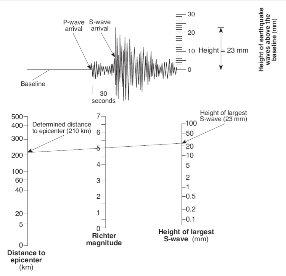
 

Figure 22. An analog diagram for calculating a Richter scale number for a local earthquake (see http://www.ntschools.org/cms/lib/NY19000908/Centricity/Domain/112/Richter%20worksheet.pdf).

Though relatively easy to understand and use, the Richter Scale is no longer commonly used because it represents just a fraction of what is going on.

There are also Mb (the body-wave magnitude), Ms (the surface-wave magnitude), and Mw (the moment magnitude). Most of these magnitudes track closely together for magnitudes of M = 2 to M = 5, but diverge for larger and smaller earthquakes. In part this is because some wave-types strongly influence a short-period or broadband seismometer (which are sensitive to higher frequencies) while another wave-types (for example, surface waves) more strongly affect older seismometers designed to optimally measure low-frequency energy in the 1 – 2 Hz range.

For large earthquakes, Mw (Moment Magnitude) is the preferred magnitude, because it more fully represents everything emanating from the earthquake hypocenter. The “moment” Mo is calculated as a product of µ (shear strength of the rocks) times S (the surface area of the fault tear, measured horizontally, times down-dip direction), and d (the displacement – how far did one side of the fault move with respect to the other side). The largest ever recorded earthquake, as mentioned earlier was the Great Chilean (Valdivia) event of May 1960, which had a moment magnitude Mw = 9.5

Confused yet? There is also Me (the energy magnitude – a measure of the potential damage to man-made structures), and Intensity (the measure of surface-shaking damage observed). They are related. Energy release is generally proportional to the shaking amplitude raised to the 3/2 power, so an increase of 1 magnitude corresponds to a release of energy 31.6 times greater than that released by the next lower earthquake magnitude. In other words,

Magnitude 3 = 2 gigajoules

Magnitude 4 = 63 gigajoules

Magnitude 5 = 2,000 gigajoules

Magnitude 6 = 63,000 gigajoules

Magnitude 7 = 2,000,000 gigajoules

What is a joule, you may reasonably ask? Energy is normally expressed in joules while power is expressed in watts. One watt is defined as 1 joule per second. A hundred-watt lightbulb, turned on for just one second, consumes 100 joules of total energy.

Both Intensity and Magnitude depend on many local variables, including surface geometry and the seismic velocities of various underlying rock and sediment units. For example, the 1985 Mexico City earthquake had a surface-wave magnitude Ms of 8.1 However, because of resonant focusing of seismic waves as the partially-dried-up Texcoco Lake basin (that Mexico City was built on) lapped onto bedrock, some buildings on one side of a city boulevard had ground motions 75 times greater than the other side (Moreno-Murillo, 1985; see also http://earthquake.usgs.gov/learn/topics/measure.php ). A friend (Mauricio de la Fuente, then a professor at UNAM, the autonomous university of Mexico) who lived through this event told me that it was amazing to stand in that street and see everything on one side standing, and everything on the other side flattened. Over 8,000 people died, mainly in buildings on that ancient lake side (the Texcoco ancient lake bed).

Intensity is very different, based on the Mercalli scale (see https://en.wikipedia.org/wiki/Mercalli_intensity_scale ). It is a twelve-level scale designed to fit observed damage. The name Mercalli is attached to a scale that Giuseppe Mercalli revised from an earlier Rossi-Forel scale, and which has been further modified multiple times since then (http://pubs.usgs.gov/gip/earthq4/severitygip.html ). On the Modified Mercalli scale, the 1985 Mexico City event scored an intensity level of IX (“Violent”) out of a possible twelve. That’s another way of saying “things could be a lot worse.”

One more thing to think about: seismologists estimate that only 1% to 10% of the energy of any given earthquake is released as seismic waves. Almost all the rest of the energy is released as heat (http://earthquake.usgs.gov/learn/topics/measure.php ). This figures indirectly into models designed to emulate the complex breaking process of a fault tear, because at some points, wall-rocks are literally welded together by the intense heat, forcing complex movements around these focal points (Dieterich, 1978; James Dieterich, personal communication 2016). This is an astonishing understanding that goes a long way towards explaining the difficult-to-model nature of a fault rupture.

Moment magnitudes are calculated by complex equations that take into account a number of factors including different velocities and different attenuation of seismic energy in different rocks. Mw takes into account pretty much everything that goes on during the rupture. If you want the gory details, see https://en.wikipedia.org/wiki/Moment_magnitude_scale .


  1. The “power of a volcano” is generally characterized as Volcano Explosivity Index or VEI. This is a relative measure of explosiveness of volcanic eruptions, and is open-ended with the largest supervolcano eruptions in pre-history (Yellowstone, Toba, Taupo) given an arbitrary magnitude of 8 in this classification system. The 79 AD eruption of Vesuvius and the 1980 eruption of Mount St Helens in Washington State are both rated a VEI 5 on this scale. The VEI number attached to a volcanic eruption depends on (a) how much volcanic material (dense rock equivalent) is thrown out, (b) to what height is it launched, and (c) how long the eruption lasts. There is no equation to calculate this scale, and in that sense it is like the Meercalli Scale. However, it is considered logarithmic from VEI 2 upwards. In other words, a VEI = 5 event represents approximately 10 times more energy released than a VEI = 4 event. Follow this link for more information on how to assess the VEI magnitude (from Newhall and Self, 1982):

https://en.wikipedia.org/wiki/Volcanic_Explosivity_Index


Chapter References:


Allaby, Michael, 2008, Saffir-Simpson scale, in: A dictionary of earth sciences (3rd ed.): Oxford University Press, 1672 pp. ISBN 978-0-1992-11944


Bormann, Peter; and James W. Dewey, 2014, The new IASPEI standards for determining magnitudes from digital data and their relation to classical magnitudes: http://gfzpublic.gfz-potsdam.de/pubman/item/escidoc:816929:1/component/escidoc:816928/IS_3.3_rev1.pdf        doi: 10.2312/GFZ.NMSOP-2_IS_3.3


Dieterich, James H., 1978, Time-dependent friction and the mechanics of stick-slip: Pure and Applied Geophysics 116, issue 4, p. 790–806. doi: 10.1007/BF00876539


Fujita, Tetsuya Theodore, 1971, Proposed Characterization of Tornadoes and Hurricanes by Area and Intensity: Satellite and Mesometeorology Research Paper 91. Chicago, IL: Department of Geophysical Sciences, University of Chicago.


Moreno-Murillo, Juan Manuel, 1995, The 1985 Mexico Earthquake: Geofisica Colombiana. Universidad Nacional de Colombia 3, p. 5–19. ISSN 0121-2974.


Newhall, Christopher G.; and Self, Stephen, 1982, The Volcanic Explosivity Index (VEI): An Estimate of Explosive Magnitude for Historical Volcanism (PDF): Journal of Geophysical Research 87 (C2), p. 1231–1238. doi: 10.1029/JC087iC02p01231.


Richter, C.F., 1935, An instrumental earthquake magnitude scale (PDF): Bulletin of the Seismological Society of America. Seismological Society of America 25 (1-2), p. 1–32.


Spence, William; Stuart A. Sipkin; and George L. Choy, 1989, Measuring the size of an earthquake, in: Earthquakes and Volcanoes 21, Number 1, 1989. http://earthquake.usgs.gov/learn/topics/measure.php
Is Water Wet?

Sometimes we get queries at Ask-a-Geologist that have little or nothing to do with geology. We find that some people have gotten wrapped up in an internet meme or conspiracy theory that is really pointless… and they come to us to arbitrate an argument. Here’s an example:

Q: Hi i was just wondering if you could answer my scientific question… is water wet?

  • Andrew W.

A: First of all, this is not a “scientific question” – it’s a semantic issue. I’d recommend you begin by checking a dictionary for the definition of “wet.” This is what *I* found in a 3-second look at www.dictionary.com:

adjective, 
  1. moistened, covered, or soaked with water or some other liquid: wet hands.
  2. in a liquid form or state: wet paint.
  3. characterized by the presence or use of water or other liquid.
This question is thus not a geologic question, but a game of English word-play.  It’s similar to the question “Is fire hot?” Well, DUHHH.
~~~~~
The larger take-away here is not to let yourself get caught up and waste time in internet memes. A substantial bulk of internet content typically has no filters – no peer-review, no foundation in historical or experimental fact. The things you find in this gray zone are like this pointless question. At least it’s one step above baseless conspiracy theories, that serve no other use than to provide click-bait advertisement income for people who resist the idea of doing any real work.
I’m reminded of the Daily cartoon in the New Yorker, from May 6, 2015 by Christopher Weyant: an unctuous member of Congress is talking to a reporter “I like to think we aren’t so much antiscience as we are pro-myth.”
~~~~~
Don’t be that kind of person. You can promote the myth or conspiracy that 1 + 1 = 3 if you want to waste air. The First Amendment to the US Constitution allows you to do so (at least in the United States). However, your math will not land a Lunar Module on the Moon, nor solve the problem of cancer. Your smart phone doesn’t work because of some made-up fact about electricity and angels. You don’t want to be the person stuffing dead air with platitudes, conspiracy theories, and pointless memes.

How To NOT Go Off-The-Wall-Freakin’ CRAZY…

…when a Cascadia Earthquake hits.

From personal experience, when a really big earthquake hits, it is extremely unnerving. In fact, my first earthquake was a magnitude 7.3 event in Southern California, and the serious shaking lasted not much more than 3 minutes.However, it seemed like a lifetime to me then. If asked a week later, I probably would have said that it lasted at least a half an hour.

Look at the following diagram, taken from Wikipedia:

The P is what woke me up. It hit with a bang.
The S is what rattled and then broke the windows, and stutter-walked my bed 30 cm across the floor.
The R is what finally flipped me out of my bed and onto the floor.

It took several days for the information on this event to filter down through the scientists to the government entities, to the news media, to my parents, and then to me as a 6-yr-old child. By then we were back in our house, the power was restored, and we had water pressure again.

A Cascadia subduction earthquake might reach a moment magnitude 9+ when it next occurs. That will be nearly 100 times more energy than the piddly 7.3 event that launched a sleepy 6-yr-old out of his bed in Bakersfield, California long ago. If I found a M=7.3 event to be that terrifying, imagine how bad a M=9+ event might feel like.

There are two ways to deal with the terror:

#1. Understand immediately what is happening and what will come next.
#2. Be prepared for it. In other words, know that you have your bases covered.

#2 is something that many people more or less do (some do OK, some do better, and some do extremely well at this):
A. Have a family plan in place. Where do we meet? What channels on the battery-powered, $40 hand-held walkie-talkies will we be using to find each other?
B. Have supplies at hand, including
i. Food. And don’t count your refrigerator contents here.
ii. Water. A LOT more water than you might think.
iii. A battery-or-crank-powered Radio
iv. Batteries. Flashlights. LOTS of batteries.
v. Blankets and sleeping bags, and/or a heat source to keep warm.
C. Start checking up on your neighbors, and offer to share your stuff with them. People you may hardly know will become life-long friends really quickly.

However, the purpose of THIS blog entry or chapter is to help you deal with #1: understand what in the world is going on, so you don’t go crazy.

Next, look at the following diagram:

This will help you to understand the TIMING difference between the several kinds of seismic waves. The P wave arrives with a bang, like someone with a large hammer just whacked one side of your house. The S wave will feel different: slewing everything back and forth, perpendicular to a line between you and the epicenter of the earthquake. The R (which stands for Raleigh, or surface) waves will feel to you like you are in a small skiff after a large boat roars past, careless of his wake. You will feel like you are rolling around, up and down, and sideways . You always end up pretty much in the same place with each complete roll.
All these things are important clues for you. This is what you do:
FIRST: as soon as the P-wave hits, look at your watch… which we both hope includes a second hand.
Second: as soon as the S-wave hits, think about what direction is PERPENDICULAR to that sickening side-to-side motion: this gives you the important clue as to where this thing is coming from. If the slewing motion is north-south, then the earthquake epicenter is either east or (more likely in this case) west of you.
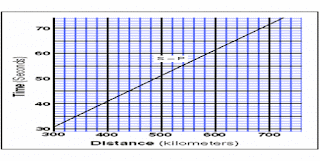
Third: as soon as the S-wave hits, look at your watch again. Subtract the P-wave arrival time in seconds from the S-wave arrival time. That difference tells you how far away the hypocenter (the actual sub-seafloor rock rupture) is from you.
Use the following diagram to convert that P-S time difference into a distance::
Fourth: KEEP TRACK OF THE TIME even after you have this number. If the event is a M=9+ event, the ground will keep shaking and heaving for a full 5 – 6 minutes. THIS will give you a sense of how bad things will be in the following several weeks. If it was just a segment of the Cascadia Subduction Fault breaking, then the time could be as little as 3 – 4 minutes. This is GOOD. If the heaving and shaking runs up to 6 minutes… well, you already have #2 above in place, right? So you are prepared.
This will help: If you live in Portland or Seattle, and the P-S time difference is 20 – 45 seconds, then the event is far enough away (or close enough, depending on your point of view) to be The Big One: A Cascadia Subduction Event.
But YOU WILL ALREADY UNDERSTAND WHAT IS GOING ON even before the first news reports start coming in (assuming you have a flashlight close and a battery-powered radio on hand). 
 
AND YOU HAVE YOUR PREPARATIONS IN PLACE.
And no, you are not crazy: you are informed and prepared.

The Coast Is Toast…

When I was a child the White Wolf Fault, a splay-fault of the great San Andreas, ruptured about 60 km (40 miles) from my home. I recall hearing a bang, then hearing the windows rattling hard – and finally breaking. Shortly afterwards, I was thrown out of bed onto the floor. I didn’t fall out of bed, I was thrown from my bed to the middle of my bedroom floor. When my mother called to me from her bedroom to come to her (she was trying to hold onto her own bed at the time), she told me that I replied “I can’t. The walls keep hitting me.” On our hands and knees we finally made it as a small family out to our back yard (my Mom was fearful of the gas line rupturing and suffocating or burning us all). This earthquake had a moment magnitude of about 7.3

The movie “Volcano” made the expression “The Coast Is Toast” famous. “Volcano” postulated a volcano somehow under the San Andreas Fault. When the film came out, my volcanologist colleagues cringed. While volcanoes ARE associated with faults, they are associated with deep subduction faults, where ocean floor is over-run by a continent in what is called a thrust fault. Think of the Cascades range, far inboard from the Cascadia subduction fault 50 – 100 kilometers offshore. The volcanoes themselves are found far inland from where the huge subduction fault reaches the ocean floor.

However, the expression “The Coast IS Toast” is not that far off the mark in the sense of massive destruction that could visit the Pacific Northwest coast if and when a Cascadia subduction event occurs. It could be a magnitude of 8.0 or 9.0 or even higher – this would represent over 100 times more energy released that what woke me up many years ago.

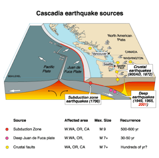
The Cascadia Subduction Zone (CSZ) is just that: a plate-subduction thrust fault spread over a 1,000 kilometer length, extending from offshore Vancouver Island in Canada to offshore northern California. It’s width depends on what you count, but earthquake imaging of the down-going oceanic slab extends well into central Washington and Oregon. Three major oceanic floor plates, the largest being the Juan de Fuca, are being over-ridden by a westward-moving North American continent. Part of the thrust fault is lubricated by the ocean-floor sediments atop the Juan de Fuca plate, and part of the down-going slab is partially melting in the upper Mantle, giving rise to that almost linear string of Cascades volcanoes. These volcanoes extend from Mt Garibaldi in British Columbia to Mount Shasta and Mount Lassen in Northern California.

But in between these parts is a segment, extending the entire length of the fault zone, that is stuck. The lubricating fluids have been squeezed out by pressure with increasing depth, and the stuck part is like a dry patch in the center of your hands as you try to slide one past the other. THIS is where the the rub lies, so to speak. In 2004 a similar subduction fault near Aceh in western Indonesia ruptured, creating a magnitude 9.3 earthquake. The tsunami alone killed over 250,000 people around the Indian Ocean as far away as Mozambique. When a similar subduction fault offshore of northern Japan ruptured in 2011, the surface area of the fault that was displaced or ripped was enormous: 300 kilometers long by 200 kilometers down-dip. This is important, because the surface area ruptured correlates closely with the energy released. “Down-dip” on the San Andreas Fault is only about 10 kilometers – because this fault is more or less vertical, and the rock becomes plastic at about 10 kilometers depth.

There is a security camera video of a 15-meter (50′) wave breaching the 5-meter (16 ft) tsunami-protection walls of the Fukushima Dai-Ichi nuclear power plant on the NE Japanese coast. If you’ve been trying to body-board in the ocean, you know how hard a 2 meter (6 foot) wave can slam you. To state the obvious, you don’t just stand your ground with even this small a wave: water is nearly as dense as your body. The estimated cost of this disaster to Japan as a nation is now in excess of $300 billion.

That sounds unimaginable. However, a Cascadia Subduction event is a very real, in fact inevitable, likelihood for the Pacific Northwest.

What will happen when this inexorable event occurs?

The coast will lurch westward 20 meters (60 feet)… and remain there permanently.

The coast will drop down on average 2 meters (6 feet)... and the low-lying parts will remain sunken permanently.

A tsunami up to 40 meters (130 feet) tall will strike coastal communities in as little as 15 minutes from the onset of the first shaking.

There will be fires that are unstoppable – because gas mains and water mains will both be ruptured. The 1906 earthquake in San Francisco was over in probably less than 3 minutes… but the fires that destroyed nearly ALL of San Francisco raged for four days afterwards. The fire department at the time was helpless – they had no water.

In the Pacific Northwest, emergency planners have estimated that 10,000 people will die, and another 30,000 people will be seriously injured.

The closer to the epicenter – a broad north-south line just off and beneath the coast – the greater the damage. The farther east you live, the greater the attenuation of the energy released by a CSZ event. Attenuation means the Earth’s crust in between the fault and, say, Yakima, Washington, will absorb most of the radiating seismic energy.

But first, the ground will suddenly jerk westward, then begin going up and down and sideways, then it will begin rolling. This will go on for 4 – 6 minutes…

It will definitely wake you up. From experience, I can tell you that a few minutes seems to go on forever.

How often does Cascadia’s fault rupture? An early study of bouma sequences (mud layering in deep-ocean coring) suggested 7 events in the past 3,500 years, so we might say an average is 500 years between mega-events. However, a recent report by Oregon State University suggests that the average time between major earthquake events may be as little as every 240 years. When was the last one?

January 1700 AD.

This event gave rise to the Orphan Tsunami in Japan, so-called because there was no felt earthquake nor approaching typhoon to provide warning before enormous waves suddenly appeared and obliterated or damaged many fishing villages along the Sendai coast. That’s over 300 years ago. This is somewhat simplified, of course, because the CSZ cannot really be treated as a single entity that always behaves along its entire length the same way. Detailed geologic mapping, in fact, suggests that there are sometimes separate ruptures along the “northern zone” and the “southern zone”… giving ‘mere’ magnitude 8.5 events.

But make no mistake: while a magnitude 8+ event may feel different from a magnitude 9.0 full-rip event (lasting “only” 4-5 minutes instead of 6), there will still be widespread damage.

The event spacing (the average of 240 years vs. the current hiatus of 315 years) suggests we are then “overdue”, doesn’t it? Not necessarily, because the spacing between previous events has been as much as 500 years. Earthquakes do not click along like clocks. In fact, we cannot predict earthquakes unless we are injecting water into wells in a tectonic region like the area north of Denver, CO. or in southern Oklahoma. For all large earthquakes, despite upwards of $100 billion spent on research over the past century, the best minds I personally know unequivocally say that current science cannot predict when an earthquake will happen.

But scientists can forecast major earthquakes. That’s a very different thing than a prediction. This means that scientists can say, based on existing data, that there is a 40% chance of another Cascadia event in the next 50 years. So… less than a 1% chance in the next year. Buy earthquake insurance or not?

What can that plausibly mean to you – realistically, practically? What can you possibly do with this information?

First, scientists CAN make reasonable estimates of what will happen during and after a Cascadia event, and you and I CAN prepare for those. This is going on right now in local and state organizations in the Pacific Northwest. Infrastructure is being examined with an eye towards what can be reinforced. Building codes have already been upgraded – then upgraded again – to help us create new roads, bridges, and buildings that will better survive such an event. There are estimates in Oregon, for instance, that a majority of bridges will be compromised or fail on coastal US Highway 101, and at least five bridges on inland interstate I-5 will fail in Oregon alone. The damage will be worse the closer one is to the coast, but in both instances it takes just one bridge in a strategic location to shut down interstate commerce. Don’t count on being able to find food on the shelves of your local supermarket for awhile… or even count on being able to GET to your supermarket. Repairs to powerlines, gas lines, roads, bridges, etc. will take time. They will happen sooner inland, and take longer in the coastal communities.

This means you should have at least 2 – 4 weeks worth of non-perishable food for each adult in your household. You should have at least two gallons of water, per day, per adult, enough to last you that whole time. A majority of people planning for a disaster forget about the water part – it’s raining all the time in the “Pacific NorthWet”, isn’t it? You should also have batteries – LOTS of batteries. A hand-crank radio will be very helpful, perhaps a lifeline. I have an FCC-issued HAM radio license and two small but powerful hand-held radios. If cell towers are down, I will be part of a local Amateur Radio Emergency Services network to help move information around from my neighborhood to the region.

Most important of all, you need to have a family plan for dealing with this – or any other catastrophe. In the short term, only you can help your family and your neighbors. It will take awhile for the country as a whole to martial the necessary resources to even partially help. Having a 72-Hour Go Kit will be appreciated when you need it.

If the example of Hurricane Katrina can be used, yes, we will recover. However, the recovery effort will consume much of the region’s GDP, and it may be more than a decade before everything is running as smoothly as before the event. New Orleans and Memphis, TN, had similar economic output in 2005. by 2015 New Orleans still has not caught up with Memphis.

We will survive. We will rebuild. We will be toast only if we refuse to do anything.

Will Yellowstone Blow?

If you’re being shot at, there is some satisfaction in knowing how often you’re being shot at. You can at least plan, and perhaps take some mitigating steps. To this end, the entire Pacific Northwest is preparing for the next magnitude 8+ subduction earthquake event by seismically retrofitting public buildings and holding “Great Shakeout” drills. This planning and preparation can be applied to volcanoes, even super volcanoes.


Q: Do geologists know when Yellowstone might erupt again? It appears to erupt at a Supervolcano level every few hundred thousand years.

 The first was: 2,100,000 years ago

Second was: 1,200,000 years ago

And the last one was: 640,000 years ago

 Are we in any danger of a fourth one?

– Brandon F


A: Yes is the short answer. Probably not in your lifetime is the long answer. There have been supervolcano eruptions moving with time along the Snake River Plain to modern Yellowstone starting at least 16.5 million years ago in southeastern Oregon.

Volcanologists in the USGS Volcano Science Center are very aware of this eruptive periodicity – we have a full-time volcanologist assigned to Yellowstone as the Scientist-in-Charge (SIC) of the Yellowstone Volcano Observatory. He works in close coordination with seismologists at the University of Utah, and with the US Park Service. Some links might be of interest to you:

https://volcanoes.usgs.gov/volcanoes/yellowstone/

https://volcanoes.usgs.gov/volcanoes/yellowstone/yellowstone_publications.html

There have been other, somewhat smaller eruptions at Yellowstone, however: The Scaup Lake rhyolite flow of 250,000 years ago, and a more recent hydrothermal blow-out about 70,000 years ago. Neither would have been trivial if you had been in the area, but they did not have the continental reach of the huge monsters you list.

You might want to check out the USGS Yellowstone hazard assessment:

Christiansen, R. L., Lowenstern, J. B., Smith, R. B., Heasler, H., Morgan, L. A., Nathenson, M., Mastin, L. G., Muffler, L. P. & Robinson, J. E. (2007). Preliminary Assessment of Volcanic and Hydrothermal Hazards in Yellowstone National Park and Vicinity. U.S. Geological Survey Open-File Report , 2007-1071, 98 p.

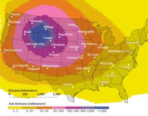
To make this a bit more real, there is a silvery-white ash deposit found all over most of the United States, sometimes called the Lava Creek Tuff (from a site locality in Kansas) or the Pearlette Ash Formation in older scientific literature. I have visited a single layer of this material near Colorado Springs, CO. There it is over 20 meters/70 feet thick; when it came down it may have been over 30 meters thick, but was consolidated with rainfall and the compressive weight of overlying material since then. This blanket of ash smothered all living things beneath it; I have personally pulled out a paleo-camel’s tooth from the bottom of the deposit. It ALL came from Yellowstone, over 800 kilometers/500 miles away!

Here’s what a future eruption might do (From Mastin, Van Eaton, and Lowenstern, 2014, “Modeling ash fall distribution from a Yellowstone supereruption”, Geochemistry, Geophysics, Geosystems, Vol 15, Issue 8, https://doi.org/10.1002/2014GC005469): 


Figure 1. Likely distribution of ash and tephra from a future Yellowstone Caldera eruption (Mastin, Van Eaton, and Lowenstern, 2014). Fine details will depend on wind distribution and the volume of the erupted ash.


Note that this is for a sophisticated 3D grid model that assumes prevailing westerly winds up to 16 – 24 km elevations. However, the model shows that the erupting plume would make its own prevailing winds, something that would allow an “umbrella cloud” to leave ash deposits throughout ALL conterminous US states, something consistent with geologic mapping of previous eruptions. 

 Another point is relevant here. Our experience is that, while you cannot predict an earthquake, you CAN predict a volcanic eruption if you have adequate instrumentation on the volcano. Several of our USGS staff returned recently from making their annual gravity and geodetic GPS survey (these surveys will detect any magmatic inflation). The caldera and surrounding terrane are very well-instrumented with telemetered seismometers, also.

The assessment of the Scientist-in-Charge when I last talked with him is that we are not likely to have a super-eruption in our lifetimes – that’s essentially what the 2007 assessment above says. I will excerpt key pieces of that assessment here:

“No volcanic eruption has occurred in Yellowstone National Park or vicinity in the last 70,000 years or more.”

“One statistical measure of eruption probabilities based on this episodic behavior suggests an average recurrence of 20,000years. The fact that no such eruption has occurred for more than 70,000 years may mean that insufficient eruptible magma remains beneath the Yellowstone caldera to produce another large-volume lava flow.”

Table 5. Estimates of annualized probability of events greater than a given magnitude.

Diameter (m)       Area (m2)    Events in last 14 thousand years     Annualized Probability

                >2                           3.1               7000 (estimated)                                   0.50

            >300                  70,700                      16                                                      0.0013

          >2000             3,140,000                        2                                                      0.00014”


This last table is from page 83 of the report. The chances for a large hydrothermal eruption next year (NOT a super volcano eruption) is just a bit over 1 in 10,000. For reasons explained above, the probabilities are likely even lower than this.

Bottom line: Those in the know are not currently worried about a Yellowstone “blow.”

A more recent paper (Lowenstern, Sisson, and Hurwitz, 2018, “Probing magma reservoirs to improve volcano forecasts”, EOS Vol. 99, No. 6, pp. 16-21) helps explain the uncertainties involved in making this assessment. Seismic tomography studies suggest that the Yellowstone magma reservoir is about 5%-15% melt, with all the rest being crystals that have slowly formed over the last several hundred thousand years. That’s still about 25 cubic kilometers of melt, larger than any volcano has spewed out on Earth since the eruption of Tambora (Indonesia) in 1815 caused the Year Without Summer in Europe, with snow in June and mass starvation following crop failures.

The current understanding in the volcanology community is that a magma reservoir is not eruptible with less than 50% melt… however, this assumes a homogeneous distribution of crystals and melt fraction. Looking closely at the steep compositional gradients in crystals erupted 250,000 years ago at Yellowstone, calculations suggest that the crystalline mush had lain dormant for ~220,000 years – but then was remobilized in as little as a mere 10 months.

The main concern is that if there is another injection of hot basalt from the mantle into the base of this reservoir, it could remobilize the reservoir and become eruptible in less than a year.

In the meantime, the volcano is very closely monitored 24/7. Please understand that there are a number of scientists within and outside of the US Geological Survey who are monitoring Yellowstone, literally, on an hourly basis. They think about your question every day. 

~~~~~

If Polar Ice Melts How Much Will Sea Level Rise?

Probably no single item brings the scientific-political argument over climate change more into focus than sea level rise and its consequences. Here are the facts to counter the “alternative facts” that have been floated in national political discourse. See also the earlier article (http://askageologist.blogspot.com/2013/07/climate-change-is-it-real.html) on “Climate Change – is it Real?” Curiously, only in America is the science of climate change being questioned. However, only in America (and Myanmar) do we still use feet, pounds, and gallons.

In all fairness, this is not an easy scientific problem to address. Non-linear behaviors (something changing much faster than the variable forcing it is changing), and extremely complex interlocking feedback between physics and chemistry related to Earth’s weather systems, makes any modeling truly daunting. Nevertheless, scientists have developed a number of predictive models, and they are beginning to agree ever more closely.

Q: What if all the ice caps melt how bad will it flood the nearby continents, and would it change the tides of the world? How fast would the world have to react.

– Stephen L

A: There are about 21 million cubic kilometers (5 million cubic miles) of ice on the Earth’s surface. If all of this melted, it would raise sea levels by about 65 meters (215 feet). An image compiled by National Geographic magazine (http://www.nationalgeographic.com/magazine/2013/09/rising-seas-ice-melt-new-shoreline-maps/) gives a breath-taking sense of what this would mean for humanity. Florida would disappear – Washington, DC, also. This isn’t going to happen immediately, of course. For all this ice to melt would require the average global temperature to rise from a current 14C (58F) to 27C (80F). This is not impossible, especially if carbon continues to be extracted and burned at current rates or higher. 

However, there are many issues beyond polar ice involved with sea level rise:

  1. Tectonic changes
  1. Thermal expansion of the oceans
  1. Melting ice
  1. Local weather events (e.g., hurricanes)
  1. Ocean albedo change
  1. Methane clathrates
  1. How fast will it rise?
  1. Tectonic changes are an issue because, all things being equal, sea level is an equilibrium by definition and should rise everywhere at the same rate. Nevertheless, the east coast of North America is seeing a greater sea level rise than the west coast. This is because of tectonic changes, related to mid-Atlantic sea floor spreading, that are causing steady (tectonic) sinking along the east coast of the United States.
  1. Thermal expansion is important because if you heat water it will expand. With climate change well underway (and isotopic studies indicate that it is largely man-made), we can expect all the world’s oceans to expand… and therefore rise. Water is at its most dense at 4 degrees Celsius. Freeze water and it will expand (this explains why frozen water pipes burst). Warm it above 4 degrees Celsius and it will also steadily expand.
  1. Antarctica is covered with ice an average of 2,100 meters (7,000 feet) thick. If all of the Antarctic ice melted, sea levels around the world would rise about 60 meters (200 feet). Arctic ice is not nearly as thick, but Greenland by itself, if all its ice melted, would increase sea level rise an additional 7 meters (20 feet).
  1. Local weather events are the most immediately attention-getting, and there are at least two different aspects to this. Warmer ocean water translates into more heat energy going into a hurricane – the storms become bigger and the destructive wind velocities become stronger. The recent Atlantic hurricane Irma is a case in point: it is the largest and strongest Atlantic hurricane ever recorded since measurements were first acquired. When its eye reached the southern tip of the Florida peninsula, it’s outer rain bands were already into Georgia – and that was just half of this monster. However, hurricanes push seawater before them and drag at their cores a huge low-pressure zone, and these give rise to what is called a “storm surge.” The storm surge for hurricane Katrina, which devastated New Orleans in 2005, caused over US$100 Billion in damage largely because its storm-surge was an additional 5 meters (16 feet) above the normal tidal differences. Add a “king tide” (when Earth, Sun, and Moon are aligned and the high tide is greatest) to a 5 meter storm surge and you have a very destructive combination. It’s like a giant, slow tsunami.
  1. If ice disappears from the poles and from Greenland, then the albedo of the Earth will change. Albedo is the percentage of the incident light or radiation that is reflected by a surface, and is typically used for a planet or moon (the Moon’s albedo is about 20%, which means about 20% of sunlight is reflected and 80% is absorbed). In this case, ice-covered polar regions are very strong (though not perfect) reflectors of sunlight. If the ice were to disappear, the energy absorption of the polar regions would increase dramatically. Like ocean warming, this is another contributor to the non-linear character of sea level rise: a simple increase in a certain value causes secondary effects that dramatically increase the effect disproportionately in a non-linear fashion.
  1. Methane clathrates (a.k.a. methane hydrates, “fire ice”, etc.) are methane-ice held in a suspended quasi-stable crystal state found in the world’s cold deep ocean sediments (below at least 200 meters or 600 feet depth). This methane is a product of carbon being sequestered over time by CO2 capture (decayed materials falling to the ocean floor). The amount of carbon sequestered in this form beneath the world’s oceans is estimated between 500 and 2,500 gigatons, comparable with all known sources of hydrocarbons (oil and gas) found on land. There is evidence now that ocean temperatures as deep as 500 meters are rising. Methane, being a far stronger greenhouse gas than carbon dioxide, if released in these numbers, will cause a dramatic rise in global temperatures. This is another contributor to the non-linear character of sea level rise, and helps explain why estimating climate change consequences is so difficult.
  1. How fast will sea level rise happen? That is the million-dollar question for our age. The Intergovernmental Panel on Climate Change issued a report in 1995 containing various projections of the sea level change by the year 2100. They estimated that average sea levels worldwide will rise 50 centimeters (20 inches), and their +/- range went up to 95 centimeters (over 3 feet). The rise will come in part from thermal expansion of the ocean and in part from melting glaciers and ice sheets. Fifty centimeters is no small amount – this could have an enormous, disproportionate effect on coastal cities, especially during storms like Katrina, Sandy, or Irma. Keep in mind that this estimate is over 20 years old, and more recent sea level rise estimates vary widely but are not small. Since that 1995 report there have been gigantic ice sheet calving events in the Antarctic. The most recent (Summer of 2017) on the Ross Ice Shelf was an “iceberg” the size of Delaware, that ranges from 15 to 50 meters (up to 165 feet) high… and it will all melt as it drifts northward.  

About 80% of the human population now lives within 100 km of an ocean, and the most expensive and sought-after kinds of land are ocean-front properties. You don’t have to be a rocket scientist to realize that ocean-front property investment might not be a good idea. Miami “dodged the bullet” from hurricane Irma in September 2017, but it’s just a matter of time before a larger, even more destructive hurricane will hit it dead center. The loss of life and property to just Miami alone are unimaginable. The entire eastern United States is at risk, and hurricane Sandy (2012) made it clear that low-lying cities like Washington DC and New York are at terrible risk due to climate change. Giant typhoons in the subtropical Pacific are causing huge damage every year to east and southeast Asia, Japan, and the Philippines. 

We should be have been reacting to these scenarios long ago. Places like The Netherlands and the City of Venice have certainly been taking steps to mitigate the consequences of sea level rise for decades now. However, the world needs to address the reason for it. Choosing myth over climate science is not the way to go. That approach didn’t work for Big Tobacco, either.


An aside: recently, a US Congressman, who probably should not be named to avoid further embarrassing him, argued against the vast and accumulating evidence of climate change, saying that sea-level rise is cause by “…rocks …falling into the sea.” [https://www.huffingtonpost.com/entry/republican-congressman-explains-sea-level-rise-its-rocks-falling-into-the-sea_us_5afef746e4b07309e057985b]

He apparently doesn’t understand the difference between a bucket and an ocean. 

~~~~~

Risks of Working in a Rock Shop

 Q: Greetings,
     I work for a small business rock shop that carries a very large variety of gemstones and minerals. I have wondered for quite some time if I should be concerned about exposure so certain elements like lead, arsenic etc. We handle mostly everything without gloves or the use of dust masks.
I am now pregnant and even more concerned about this. I know that doctors and other professionals will advise the use of safety precautions regardless. My question is not that if we should use precautions, because I know that we should anyways. The question I am asking you, is if there is plausible serious risk through skin contact and inhalation? Do you know of any risks, are you able to provide specific examples of situations where problems have occurred /or might occur?
One example is of the handling of iron pyrite. It leaves behind black residue (we do use gloves for this) and creates a strong smell and dust in the air. Am I exposing myself to something serious here?
Also, I’ve heard of a new fad where the folks who believe in metaphysical properties of stones are putting them in their drinking water. I found this alarming.
I look forward to your response! Thank you for your time.
Thank You,
– Stacey S.
~~~~~
A: This is a VERY important query, and kudos to you for asking – and for your  determination to protect your unborn baby.
 
YES. There are minerals that are really dangerous: realgar and orpiment have mercury in them, for example. You can look up Minamata Syndrome to get an idea of how bad these could be to a fetus: https://en.wikipedia.org/wiki/Minamata_disease 
 
YES. There are various forms of asbestos that kill – literally. My father died a premature death from lung cancer. The biopsy showed that there was asbestos in his lungs, ultimately traced to dust in the basement of his apartment building in San Francisco where he kept his bicycle. The pipes had been insulated with spray-in asbestos in the 1950’s when the building was originally constructed. I’d be willing to bet that the workers who blew in that insulation preceded him.
 
POSSIBLY. Pyrite (FeS) is a mineral that will oxidize in the atmosphere. The bright shiny mineral faces will eventually dull and then go brown. The smell you describe is probably H2S, normally not toxic in small amounts (the smell warns us to get away – this is common around volcanoes I’ve worked in). My concern is that there are other sulfides that are often naturally associated closely with the pyrite, including cadmium and arsenic sulfides. These are very poisonous.
 
You are probably safe handling gemstones and semi-precious stones such as citrine, zircon, beryl, and amethyst – these are typically hard minerals that do not interact much with the environment nor degrade with time, which is why they are valued in the first place. 
 
I would encourage you to think more about a high-quality respirator when in a dusty, mineral-laden room. Inhalation is probably a more serious threat than getting the stuff on your hands… unless (like me) you always have an itchy nose and rub it frequently. Here is a website that will get you started on the various kinds of respirators out there (they run the gamut from the kind your dentist uses to serious industrial equipment): https://www.osha.gov/OshDoc/data_Hurricane_Facts/respirators.pdf 
 
Putting stones and gems in drinking water also boggles MY mind. A diamond will not react, and most semi-precious stones won’t either… but everything else WILL react with water to some degree, especially if the water’s slightly acidic (think Coke or Pepsi for acidic fluids). Putting crystals on your body is silly enough… now imagine bright yellow or red minerals in your drinking water!
 
I hope this helps. I personally love rock shops and as a geophysicist visit them whenever I can. I DO wash my hands after I leave one, however. 
~~~~~

General Planetary Geology Q&A

Q: To Whom It May Concern

I’m not a scientist, however I find it an interesting issue.

I have a few questions of which I hope you can clarify for me:

– Preben P


A: I’ll try to respond to each of your questions below in CAPS:

Q: 1: How does the inner core of the earth maintain its temperature? Or is it decreasing?

A: FOR ONE THING, THE CORE OF THE EARTH IS WELL INSULATED WITH VAST VOLUMES OF LOW-THERMAL-CONDUCTIVITY OVERLYING ROCK. EVEN WITH CONVECTION IN THE MANTLE (AND PERHAPS THE OUTER CORE ALSO) IT TAKES A LONG TIME FOR HEAT TO ESCAPE. WHETHER THE TEMPERATURE IS INCREASING OR DECREASING IS A MATTER OF CONJECTURE. SOME OF THE HEAT IS FROM KINETIC ENERGY DUE TO THE AGGREGATION OF THE PROTOPLANETARY DISK, WHICH WOULD IMPLY COOLING. HOWEVER, MUCH OF THE HEAT IS THOUGHT TO BE FROM DECAYING RADIOACTIVE ISOTOPES… WHICH WITH THE ONSET OF CONTINENTAL DRIFT (MANTLE CONVECTION) IN THE PRECAMBRIAN IMPLIES INCREASING HEAT. MANKIND HASN’T BEEN AROUND LONG ENOUGH TO TELL THE DIFFERENCE. 

Q: 2: After any volcano eruptions what happens to the void space from whatever is discharged?

A: USUALLY A CALDERA REMAINS – A LARGE SUNKEN CRATER – OR SOME OTHER COLLAPSE FEATURE APPEARS. OVERLYING LITHOSTATIC PRESSURE GUARANTEES THAT NO VOIDS REMAIN INSIDE THE EARTH – THERE IS NO VOID SPACE ANYWHERE IN THE EARTH EXCEPT FOR VERY SHALLOW CAVES CAUSED BY LIMESTONE DISSOLUTION (KARSTS). 

Q: 3: Could it be possible that earth is a dying sun meaning that the earth for billions of years ago was a burning planet from big bang? Just like the sun as we know it today.

A: THE SUN AND EARTH DID NOT BEGIN TO FORM UNTIL ABOUT 9 THOUSAND MILLION YEARS *AFTER* THE BIG BANG, SO THE EARTH IS NOT HOT FROM THE BIG BANG (AT LEAST NOT DIRECTLY). AS AN ASIDE, EARTH IS NOT A SUN.

NOTE: a thousand million = billion in America. A million million = a billion in the UK.

THE SUN IS USING UP ITS HYDROGEN FUEL AT A RATE THAT WILL LEAD TO A NOVA IN ABOUT 5 THOUSAND MILLION MORE YEARS. THERE IS SOME EVIDENCE THAT THE EARTH WENT THROUGH A FROZEN “SNOWBALL” STAGE IN THE ARCHEAN EPOCH (MORE THAN ~2,500,000,000 YEARS AGO), BUT THIS IS POORLY UNDERSTOOD (THE EVIDENCE IS TRULY ANCIENT). THERE IS EVIDENCE (STROMATOLITE FOSSILS) THAT THE EARTH RESIDED IN A TEMPERATE ZONE LIKE TODAY AS FAR BACK AS ~3,400,000,000+ YEARS AGO.

Q: Climate change:

Don’t believe its cause by man; for sure man is the cause of poor air quality.

A: IF YOU DON’T ACCEPT THE VAST AND GROWING EVIDENCE FOR CLIMATE CHANGE, THEN YOU ARE PART OF A VERY SMALL MINORITY AMONG EDUCATED PEOPLE. 

MORE THAN 98% OF SCIENTISTS WHO STUDY CLIMATE CHANGE AGREE THAT THE EVIDENCE STRONGLY INDICATES THAT MAN IS THE CAUSE OF CLIMATE CHANGE. THE RAPIDLY GROWING CO2 IN THE ATMOSPHERE, A WELL-MEASURED GREENHOUSE GAS, HAS AN ISOTOPIC SIGNATURE LOW IN CARBON-14: THIS MEANS MOST IF NOT ALL OF THE NEW CO2 WAS SEQUESTERED FOR A MINIMUM OF 50,000 YEARS AS BURIED HYDROCARBONS, AND MORE LIKE HUNDREDS OF MILLIONS OF YEARS. IT IS RELATIVELY EASY TO CALCULATE THE AMOUNT OF FOSSIL FUEL BURNED IN THE PAST CENTURY, AND TIE IT TO THE INCREASE IN CO2. HOWEVER, THE HUNGER FOR MEAT PROTEIN HAS ALSO MEANT AN EXPLOSION OF DOMESTIC RUMINANTS (SUCH AS COWS) THAT EMIT VAST AMOUNTS OF METHANE, A GREENHOUSE GAS UP TO 37 TIMES MORE POTENT THAN CO2. ONE COW EMITS AS MUCH METHANE IN ONE DAY AS THE VOLUME OF THREE OF MY FILING CABINETS. MULTIPLY THAT BY 37 TO GET THE EQUIVALENT CO2 RELEASE. THE GEOLOGIC RECORD SHOWS THAT THERE HAVE BEEN CLIMATE CHANGE EPISODES IN THE PAST, BUT NONE THAT HAPPENED ANYWHERE NEARLY AS FAST AS IT IS HAPPENING RIGHT NOW – IT TOOK HUNDREDS OF THOUSANDS OF YEARS INSTEAD OF OUR CURRENT HYPER-SPEED, CHANGE-IN-A-CENTURY RATE). 

I CONCUR WITH YOU THAT MAN IS DEFINITELY THE CAUSE OF POOR AIR QUALITY. 

Q: How about magnetic poles so when the suns positive pole is close to earths negative it will bring the 2 closer and opposite when negative is close to negative also the moon must have effect there.

A: YOU ARE THINKING OF HOW BAR MAGNETS BEHAVE CLOSE TO EACH OTHER – THIS IS A FAULTY ANALOGY BECAUSE OF FACTORS OF BOTH SCALE, PROCESS, AND DISTANCE. THE SUN IS 144,000,000 KILOMETERS FROM THE EARTH. THE SOLAR WIND *DOES* INTERACT WITH THE MAGNETIC POLE OF THE EARTH (AURORAS). THE STRENGTH OF THE SOLAR MAGNETIC DIPOLE IS FAR TOO SMALL TO INFLUENCE THE EARTH’S MAGNETIC DIPOLE, WHICH IS APPARENTLY DRIVEN BY THERMAL CONVECTION IN THE CORE OF THE EARTH. 

Q: PS: Science is like religion you either believe in it or not, however science has a few fact but if they come off wrong at the start everything is wrong

A: I PARTIALLY AGREE WITH YOUR PS: *SOME* PEOPLE ATTEMPT TO MAKE SCIENCE THEIR RELIGION. I DON’T THINK THAT IS WISE, BUT I UNDERSTAND HOW IT CAN HAPPEN. I AGREE THAT FAULTY SCIENCE CAN LEAD TO FURTHER MISTAKES, LIKE HOW SOVIET GENETICS WAS CRIPPLED FOR DECADES BY THE SO-CALLED STALINIST GENETICIST LYSENKO. HOWEVER, WHILE SCIENCE IS THEORETICALLY A SELF-CORRECTING PROCESS, IT IS NEVERTHELESS IMPERFECT, A VERY HUMAN PROCESS. IT SHOULD THEREFOR NOT BE WORSHIPED. 

IF YOU DON’T BELIEVE IN SCIENCE THAT IS FINE, BUT IT MARKS YOU AS SOMEONE WHO HAS NOT STUDIED AND LEARNED ENOUGH TO UNDERSTAND IT. YOU CAN ALSO CHOOSE TO NOT BELIEVE IN GRAVITY, HOWEVER IF YOU THEN STEP OFF THE TOP OF A BUILDING YOUR BELIEF WILL NOT MAKE IT GO AWAY. 

One final comment. Everyone is entitled to an opinion. However, if you base your life and actions on opinions not backed up by facts, you will not live long nor well. MAKING UP facts doesn’t make them facts. You can believe that 1 + 1 = 3 but your orbital mechanics BASED ON THAT MATH will not land a man on the Moon.